

Gujarat Advanced Polygon Land Calculator: Complex Tedi-Medi Zameen ka Sateek Hisab
Irregular polygon land mapping for Gujarat. Calculate accurate conversions dynamically into Vigha, Guntha, and Hectares.
1. Introduction to Irregular Land Formations in Gujarat (Jamin ni Mapni Background)
Gujarat mein zameen ki boundaries aur geographical plots ka landscape kafi dynamic aur pechida hai. Alag-alag districts aur terrain variations, localized slopes aur sadiyon purane village dynamics ke karan, yahan ki 90% se zyada agriculture field holdings aur residential properties perfectly symmetrical rectangle ya square space me nahi hoti hain. Jab kisi land plot asset me 4 se zyada irregular corners (konne) hote hain, toh use mathematical language me hum Polygon (બહુકોણ) ka naam dete hain. Aisi tedi-medi zameen par normal length × width scaling rules apply karne par standard area values hamesha wrong aate hain, jisse property mutation processing me legal anomalies open up ho jati hain.
Gujarat Revenue Department (AnyROR portal guidelines) ke anusar, registration metrics validation ke waqt land parameters ka sateek assessment hona behad mandatory hai. Is issue ko scientifically resolve karne ke liye engineering structures me Multi-Triangle Polygon Geometric Mapping system use kiya jata hai. Shayan Smart Tools ne isi multi-triangulation rule ko code framework par mapping karke is advance **Gujarat Advanced Polygon Land Calculator** portal build kiya hai taaki amari kisan bhai bina kisi layout error ke zero validation lag ke sath single second calculations execute kar sakein.
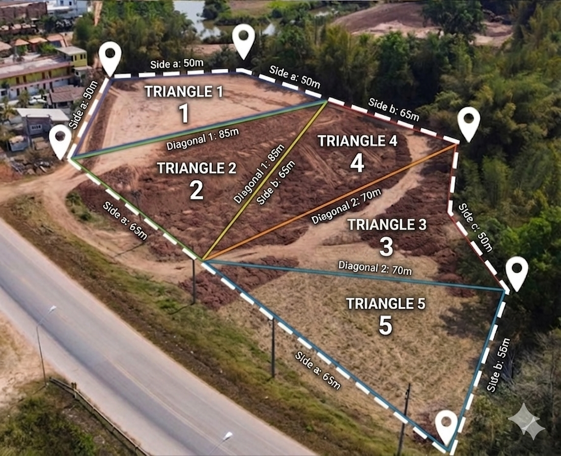
2. Geometric Methodology: The Power of Multi-Triangle Method and Heron's Formula
Irregular polygon plots ka sateek framework map evaluate karne ka sabse ancient aur globally certified system hai bada asset patch ko chhote independent right/irregular triangles me convert kar dena. Jab aap apni tedi zameen ke dastawez ya ground map coordinates par diagonals lines draw karte hain, toh complex data boundaries discrete triangles blocks me slice down ho jati hain. Geometric patterns me jackpot kisi triangle ki teeno sides data variables (Side A, Side B, Side C) completely secure mil jayein, toh geometry ka sabse powerfull calculation standard Heron’s Formula apply kiya jata hai:
s = (a + b + c) / 2
Area = √(s(s - a)(s - b)(s - c))
Hamara system back-end script loop par har ek individual triangle ka sateek area parameter trace down karke unhe dynamically secure accumulate (sum up) karta hai. Final output value derive hone par use standard parameters conversion factor rules ke anusar Gujarat revenue standards (Vigha, Guntha) me flat badal deta hai. Niche diya gaya master chart dynamic mapping constants specifications ko strictly project karta hai:
Gujarat Land Unit Table (ગુજરાત જમીન માપણી કોષ્ટક)
| Unit Name (નામ) | Sub-unit Structural Relation | Area in Square Feet (ચોરસ ફૂટ) | Area in Square Meters (ચોરસ મીટર) |
|---|---|---|---|
| 1 Vigha (વીઘા) | 24 Guntha standard local unit metrics | 23,760 Sq Ft | 2,207.22 Sq M |
| 1 Guntha (ગુંઠા) | 121 Square Yards (33ft × 33ft) | 990 Sq Ft | 91.97 Sq M |
| 1 Acre (એકર) | 40 Guntha standard regional units | 39,600 Sq Ft | 3,678.92 Sq M |
| 1 Hectare (હેક્ટર) | 2.471 Acres standard metrics | 1,07,639 Sq Ft | 10,000 Sq M |
3. Landmark Identification Features: AnyROR, 7/12 Utara, and Khata Number
Zameen ka polygon spatial framework areas calculate karne ke sath-sath, har ek user ko revenue documents analytics inside me track hone wale dynamic indexing tags ki verification parameters path clear hona mandatory hai:
A. 7/12 Utara (સાત બાર નો ઉતારો): Yeh asset structure title framework ledger copy hota hai. Is identification reference sheet se track kiya jata hai ki standard circle records inside me property allocations kis continuous legal name par verified state me working me chal raha hai.
B. Survey / Block Number (સર્વે નંબર): Yeh tracking core mapping scale number hota hai. Gujarat mapping systems me state land advisory panel survey lines par har unique patch block ko ek specified layout map coordinates numeric system continuous key deta hai jise Survey number bolte hain. Is key ke bina geographic positioning assignment execute nahi ho sakti.
C. Khata Number (ખાતા નંબર): Patwari records inside running ye document classification metrics hold karta hai jo land characteristics properties aur owner registration accounts check up karne ke liye use hota hai.
4. Operational Grid Manual: Add and Compute Multiple Triangles Cards
Hamne is processing interface core framework module par structural responsive client logic indexing setup kiya hai taaki zero lag script iteration system load instantly working framework pick kar sake. Iska dynamic navigation setup is prakar execute chalta hai:
- Language Interface Switcher Nodes: Panel controls link header lines up par active press trigger se aap settings me **English** ya **Gujarati (ગુજરાતી)** parameter layout options select kar sakte hain. Pura labelling criteria automatic synchronizations format loop update ho jayega.
- Triangle Generation Layer: Initial layer par dynamic window inside 1 single triangle field parameters show hote hain. Agar aapki ground mapping layout area bada hai toh computational path line options control block up box inside **"+ Add Triangle"** key use karke unlimited metrics fields rows setup cards parallel generate kar sakte hain.
- Data Fields Configuration: Apne manual tape survey scaling charts numbers inspect up karein aur continuous values inputs entries sections side columns lines up parameters inside fields inputs secure feed out karein.
- Absolute Processing trigger: Sub data strings parameters fields inside mapping clear set tracking complete karne ke baad master call system command trigger row **"Calculate Total Area"** option use karein. System back-end parameters constants execute processing layers active block clear out kar dega.
- Cloud Transmission controls: Result analytics dashboards window layers checks parameters panel block metrics inside aap immediate actions checks variables loop connectivity link lines use karke invoice description parameters instant **Copy** parameters context map copy update hold kar sakte hain ya fir dynamic WhatsApp sharing logic code setup parameters line integration settings use karke detail data parameters links forward execute kar sakte hain. Paper file systems hard print out generation setup features updates framework configurations context inside me dynamic encryption keys specifications trace layout data ke sath professional **Print Report** infrastructure option running format inside dynamic fully operational active state ready chalta chal raha hai.
5. Frequently Asked Questions (FAQs) - Gujarat Land Records & Area Converter
Q1. Gujarat mein 1 Vigha kitne Guntha ke barabar hota hai?
Ans: Official revenue guidelines ke anusar Gujarat mein standard Vigha 16 Guntha ka hota hai, par traditional custom ya tedi-medi zameen ki continuous native map registry ke hisab se kuch jagah par 24 Guntha ka Vigha (Bada Bigha) bhi upyog kiya jata hai.
Q2. AnyRoR Gujarat portal par land area kis unit me record rehta hai?
Ans: Gujarat government ke AnyRoR portal par zameen ka area hamesha metric system yani Hectare-Are-Sq. Meter (હેક્ટર-આરે-ચોરસ મીટર) format mein save kiya jata hai.
Q3. How to convert Hectare to Acre accurately in Gujarat?
Ans: 1 Hectare standard conversion matrix me 2.4711 Acres ke barabar hota hai. Apni jameen ke Hectare area ko Acre me badalne ke liye use sidhe 2.4711 se multiply karein.
Q4. Gujarat mein ek Acre mein kitne Square Feet (Sq Ft) hote hain?
Ans: Land measurement laws ke mutabik 1 Acre mein poore 43,560 Square Feet hote hain. Lekin local 23,760 custom scale ratios me iska distribution Guntha blocks ke hisab se convert hota hai.
Q5. 1 Guntha kitne Square Feet ke barabar hota hai?
Ans: Standard survey calculations ke anusar 1 Guntha ka size 1,089 Sq Ft (33 ft × 33 ft) hota hai. Lekin traditional 24-Guntha system calculations me local conversion factor 990 Sq Ft apply kiya jata hai.
Q6. Sateek calculation ke liye land mapping me Heron's Formula kyu lagaya jata hai?
Ans: Jab kisi zameen ya plot ka aakar perfectly चौકોર (Square/Rectangle) nahi hota, tab normal mathematical formulas fail ho jate hain. Heron's Formula zameen ko irregular triangles me divide karke zero margin of error ke sath exact area nikalta hai.
Q7. AnyRoR Gujarat website se digital 7/12 (Satbara) Utara kaise download karein?
Ans: AnyRoR Any Records Anywhere website par jao, Rural Land Records select karo, fir apna District, Taluka, Village aur Survey Number dalkar captcha enter karne par aapka 7/12 Utara digitally display ho jayega.
Q8. 1 Hectare mein kitne Square Meters hote hain?
Ans: Metric measurement rules ke anusar 1 Hectare pure 10,000 Square Meters (ચોરસ મીટર) ke barabar hota hai.
Q9. Gujarat me Bada Vigha aur Chota Vigha mein kya antar hai?
Ans: Chota Vigha aamtaur par 16 Guntha (17,424 Sq Ft) ka hota hai jo central parts me chalta hai. Bada Vigha custom metrics me 24 Guntha (23,760 Sq Ft) ka hota hai jo agricultural calculations me purane zamane se chal raha hai.
Q10. Polygon Calculator se tedi-medi zameen ka area nikalne ki process kya hai?
Ans: Zameen ke tedi lines ke beech me diagonals check karke use alag-alag triangles me baantein. Un sabhi triangles ki teeno sides ka naap (Feet me) is tool me add karke calculate par click karein, sateek reports ready ho jayegi.
Q11. 7/12 utara mein land area check karne ke liye Survey Number kyu jaroori hai?
Ans: Survey Number ya Block Number land map records ka ek unique identifier code hota hai, jiske bina government digital system aapke land polygon ya registry data ko filter nahi kar sakta.
Q12. Shayan Smart Tools Polygon Calculator output data kitna reliable hai?
Ans: Yeh system advanced mathematical algorithms aur Heron's core engine standard matrix par base hai jo mathematical data ke liye 100% accurate hai. Haalaanki official boundary adjustments ke liye government certified DILR map maps valid hote hain.
Q13. 1 Guntha me kitne Square Meters hote hain?
Ans: Standard metric layout ke hisab se 1 Guntha lagbhag 101.17 Square Meters ke barabar hota hai, jabki traditional local computations me ise 91.97 Square Meters ke aspas benchmark kiya jata hai.
Q14. What is Khata Number (ખાતા નંબર) in Gujarat revenue system?
Ans: Khata Number ek specific identification registry text hota hai jo ek hi parivar ya kisan ke naam par registered saari jameeno ke total ledger aur details ko ek sath track karne ke kaam aata hai.
Q15. Calculator panel me 'Initial Data Grid Input' ka kya matlab hai?
Ans: Iska matlab hai ki aapne poore complex plot ka accurate layout map generate karne ke liye abhi tak total kitne triangulated elements ya sliced parts ka measurements coordinate feed kiya hai.
Related Tools & Internal Dashboards
🚫 Copyright & Legal Notice Protected
Copyright © 2026 Shayan Smart Tools. All Rights Reserved.
Is advanced multi-triangle polygon software application core module interface layout model framework system flow lines computational algorithms source code elements configuration settings data parameters parameters rules Muksidul Islam ke proprietary engineering copyright tracking control security guidelines elements properties hold rules privileges context me system locks and standard security managed rules structures privileges protected status systems execute rests hain. Unauthorized digital copying, parsing scripts replication mirror deployment strictly cyber laws offense acts context trace penalties limits action operations generate criteria data limits rules tracking standard legal execution line bounds monitoring ready monitor rules clear chalta hai.