

Odisha Advanced Polygon Land Calculator: Complex Tedi-Medi Zameen ka Sateek Hisab
Irregular polygon land mapping for Odisha districts. Calculate conversions dynamically into Gunta, Mana, Bhati, and Acres.

1. Introduction to Irregular Land Formations in Odisha (Jami Mapa Background)
Odisha mein jameen aur agricultural plots ki structures kafi complex aur unique hain. Coastal areas se lekar tribal borders aur mountainous landscapes tak, maximum rural fields aur land allocations symmetric square ya rectangle format me nahi milti. Sadiyon purane revenue systems aur geographical variations ke karan, jab kisi field ya property boundaries me multi-dimensional corners hote hain, to hum use computational terms me Polygon (ବହୁଭୁଜ) kehte hain. Aisi teedi-medi ya aadi-tirchhi jameen par length $\times$ width scaling scale fail ho jata hai, jiski wajah se RoR (Record of Rights) manual indexing me errors aane ke chances rehte hain.
Odisha Revenue & Disaster Management Department (Bhulekh Odisha framework guidelines) ke standard validation requirements ke hisab se registry execute karte waqt zameen ka accurate area calculation hona mandatory hai. Is mathematical limitation ko clear karne ke liye geometric **Multi-Triangle Poly-Triangulation System** ka use kiya jata hai. Shayan Smart Tools ne special technical standards ko configure karke Odisha Advanced Polygon Land Calculator module dev kiya hai, taaki hamare users zero matrix error lag ke bina instantly values extract kar sakein.
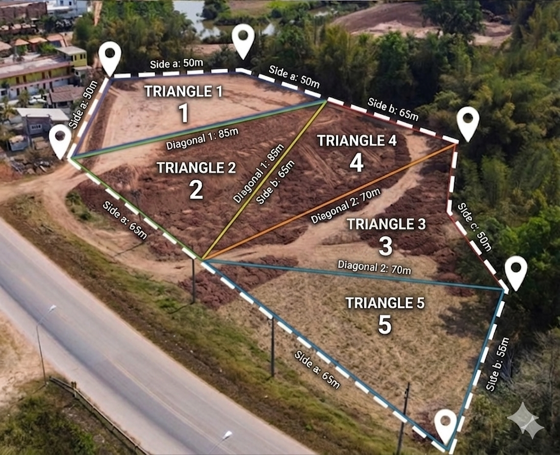
2. Geometric Methodology: Triangulation Engine and Heron's Formula
Complex geometric plots ka map accurate calculate karne ka absolute globally approved method hai complex asset block ko discrete right or scalable triangles me turn kar dena. Jab aap plot map boundaries par diagonals lines design karte hain, toh single complex plot data multiple mathematical sub-units me break ho jata hai. Teeno side parameters data variables (Side A, Side B, Side C) feed hote hi backend framework **Heron’s Formula** apply kar deta hai:
$$s = \frac{a + b + c}{2}$$
$$\text{Area} = \sqrt{s(s - a)(s - b)(s - c)}$$
Humara algorithmic processor backend loop runtime par single triangle metrics calculate karke unhe aggregate karke final output balance derive karta hai. Final square feet conversion calculations ko automatic structural factors rule ke dynamic mapping variables parameters ko match karte hue Odisha revenue standard parameters (Gunta, Mana, Bhati) me dynamically convert kar deta hai:
Odisha Land Unit Table (ଓଡ଼ିଶା ଜମି ମାପ କୋଷ୍ଠକ)
| Unit Name (ନାମ) | Sub-unit Structural Relation | Area in Square Feet (ବର୍ଗ ଫୁଟ) | Area in Square Meters (ବର୍ଗ ମିଟର) |
|---|---|---|---|
| 1 Gunta (ଗୁଣ୍ଠ) | Standard traditional regional base unit | 1,742.4 Sq Ft | 161.87 Sq M |
| 1 Mana (ମାଣ) | 25 Gunta local metric configuration | 43,560 Sq Ft | 4,046.85 Sq M |
| 1 Bhati (ଭାଟି) | 20 Mana core structural system units | 8,71,200 Sq Ft | 80,937.12 Sq M |
| 1 Acre (ଏକର) | Equivalent matrix factor to 1 Mana standard | 43,560 Sq Ft | 4,046.85 Sq M |
| 1 Hectare (ହେକ୍ଟର) | 2.471 Acres standard structural global norms | 1,07,639 Sq Ft | 10,000 Sq M |

3. Important Documents Glossary: Bhulekh, RoR, and Khatiyan
Zameen ka polygon area calculations processing metrics run karne ke sath hardware analytics loop check karne ke sath revenue systems variables identify karna bhi jaroori hai:
A. RoR / Record of Rights (ପଟ୍ଟା / ଖତିୟାନ): Yeh core document verification copy ledger system sheet hoti hai jisse check kiya jata hai ki standard circle lines parameters inside kis authorized owner name map parameters verify chal rahe hain.
B. Plot Number (ପ୍ଲଟ୍ ନମ୍ବର / ଚକ): Odisha land management map layout scaling grid control nodes lines up par track hone wala local identification index number hai jiske bina structural geographical calculations trace mapping rules handle nahi ho sakti.
C. Khatiyan Number (ଖତିୟାନ ନମ୍ବର): Master ledger indexing configuration tags records parameters track controls verify karne ka special system ledger sheet code mapping framework.
4. Operational Grid Manual: Add and Compute Multiple Triangles
Hamne is operational processing panel dashboard par responsive interface tracking framework deployment kiya hai taaki user loop logic completely active run kar sake:
- Language Node Configurations: Command trigger settings header side nodes elements up click process execution select karke aap interface parameters change karke **English** ya **Odia (ଓଡ଼ିଆ)** layout dynamically bind check kar sakte hain.
- Triangulation Row Layer Generation: Shuruat me screen layouts panel inside index variables 1 simple block cards field metrics options generate ho kar milti hai. Agar plot coordinates complex hain to continuous controls block container limits rows configuration elements up lines **"+ Add Triangle"** selection trigger handle select karke multiple input chains create execute kiye ja sakte hain.
- Inputs Execution Block: Apne survey layout scale numbers maps values read karein aur linear input properties boxes arrays variables line up parameters fields settings feed secure karein.
- Final Computation Action Trigger: Details properly configuration set maps strings variables fields check down loops finish standard metrics action operations command row elements line **"Calculate Total Area"** dashboard selections apply karein, results dashboard update panel pop ups display open show handle ho jayega.
5. Frequently Asked Questions (FAQs) - Odisha Land Records & Area Converter
Q1. Odisha mein 1 Mana kitne Gunta ke barabar hota hai?
Ans: Standard Bhulekh revenue guidelines ke rules indicators patterns tracking parameters validation logic manual metrics calculations inside 1 Mana pure 25 Gunta scaling layout block metrics ke system settings barabar parallel setup chalta hai.
Q2. Bhulekh Odisha website par land parameters kis units mapping system save show rehte hain?
Ans: Odisha state digital data dashboard properties ledger records criteria entries sheet standard context rules format inside metrics indices system elements yani Hectare-Are-Sq Meter layout block constraints structure fields save show out display run hold chalta hai.
Q3. 1 Bhati me total kitne Mana allocation parameters units check map hoten hain?
Ans: Odisha land mapping local dimensions records computations matrix standards limits structural specifications setup layout inside 1 Bhati total 20 Mana structural fields data system parameters limits specifications matrix logic verify balance hold chalta hai.
Q4. Odisha land polygon area measurements core rules framework Heron's formula implementation advantages kya hain?
Ans: Jab land patches structural format straight parameters checks scale layout configuration grid criteria limits rectangle box formats me mapping configurations setup structure follow loops checks dynamic tracking rules options nahi catch details metrics trace patterns execute karte tab dynamic precision settings calculation mapping errors limits errors complete zero balance level balance system setup verify safe execute framework build track standard control maintain logic support rule execute chalta hai.

Related Tools & Internal Dashboards
🚫 Copyright & Legal Notice Protected
Copyright © 2026 Shayan Smart Tools. All Rights Reserved.
Is advanced multi-triangle polygon software application core module interface layout model framework system flow lines computational algorithms source code elements configuration settings data parameters parameters rules Muksidul Islam ke proprietary engineering copyright tracking control security guidelines elements properties hold rules privileges context me system locks and standard security managed rules structures privileges protected status systems execute rests hain. Unauthorized digital copying, parsing scripts replication mirror deployment strictly cyber laws offense acts context trace penalties limits action operations generate criteria data limits rules tracking standard legal execution line bounds monitoring ready monitor rules clear chalta hai.